Salton Sea State Recreational Area
January 27, 2013 and January 25, 2017
Yep, one web page is describing two trips almost exactly four years apart. Otherwise, there would be two pages that are almost identical in content – hardly worth the effort.
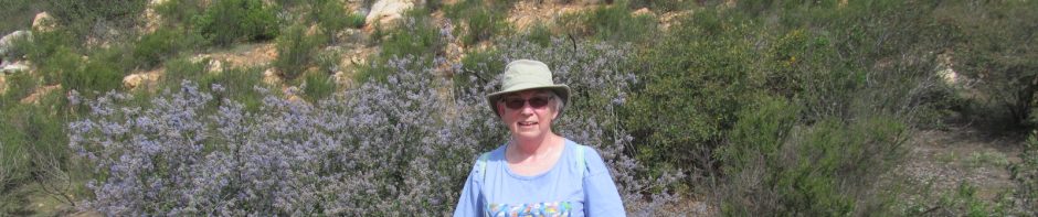
As we were checking out possibilities for amusing ourselves back in 2013, we realized that we were really close to the Salton Sea, something that I had read about decades ago in my extensive National Geographic magazine collection (which has now been given away). It is only about a half-hour drive away from Indio, where we were staying both trips. In 2017, we decided to visit it again, knowing that it is pretty easy for me, although this time we walked on the beach more, which is kind of hard on my knees (hence the tag MostlyEasy for this post).

A history/geology lesson
The Salton Sink basin was originally the northern part of what is now the Gulf of California. Because it is below sea level (227 feet below sea level, to be exact), sometimes rivers would flow into it, and sometimes even the gulf waters would flow into it. But nothing ever flows out of it!
During the late 1800s, California needed water for agricultural irrigation. The Colorado River was tapped for this purpose, irrigating the Imperial Valley.
But the powers that be had not provided an effective method for dealing with irrigation runoff or high water levels. In 1905, after an unusually wet winter, the Colorado River broke through poorly constructed canals and gates. For about 8 months, the river’s entire volume poured unchecked into the nearest low spot – the Salton Sink. Water inundated entire communities.
And, since the water had no place to go, the Salton Sea remains. It is large enough that at some points, the earth’s curvature hides the opposite shore. It is 35 miles long and 15 miles wide.
And the Sea gets saltier and saltier.
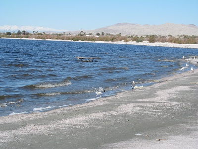
This is what the shoreline looks like, crusty with salt.

The curious reader can learn more about the Salton Sea at these links:
Our visits
After we arrived at the Salton Sea State Recreational Area in 2013, one of the first things that we noticed were (yuck!!) dead fish. Lots of them. (We also saw them in 2017, but chose not to waste digital film on them.) As we strolled around in 2013, we noticed a sign that suggested that these are Tilapia, which will die if the water gets too cold or has too little oxygen. Occasionally, Tilapia get a disease called Vibrio that kills the fish and the birds that eat them. When this happens, you may see dead fish or birds on the shore. We saw a LOT of dead fish, but no dead birds. Shut your eyes if photos of dead fish gross you out!


One interesting thing about the beach – it doesn’t appear to be sand – it seems to consist of well-trodden bits of fish spines and whatnot. Lots of dead fish, as I said…
On our 2017 visit, we really noticed snow in them thar hills!


We also noticed that in the intervening 4 years, someone had planted a picnic bench in the lake:
The Salton Sea is a birdwatcher’s paradise. I claim to be able to recognize only robins, crows, and magpies. In 2013, we bought a bird guide, so now I can tell you what these are. Except that we left it at home in 2017, so I’m back to guessing for this trip.
First, a couple of Western Grebes.

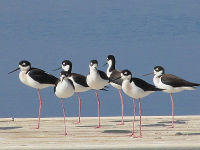
A collection of Black-Necked Stilts, some of whom are standing on only one leg – those are looooong and skinny legs!
And the same Black-Necked Stilts with a common Western Gull checking them out.

In 2017, I didn’t have the bird guide, so all I know is that these are pelicans, probably related to the ones that end up at the Bow River weir in Calgary.


And some bitterns.


And a couple of movies from 2013. The first just shows a duck diving into the water and not resurfacing. So the movie is mostly just water!
This movie shows a bunch of floating birds. They seem to float higher in the water than that would in normal non-salty lakes.
The Ironwood Nature Trail
The park has a few campgrounds in it, and they have provided an interpretive nature trail between a couple of them. The trail is about a mile each way.
Now, my ideal walking trail is through a lovely forest. This was no forest!
My ideal walking trail doesn’t have much of a downhill aspect to it. This trail was flat!
Here’s the trail with its scenery.


From the trail, we could see the Sea! (There is a song with that line – Ocean Front Property…)

You might have noticed some posts along the trail. This is an interpretive nature trail. All those posts have numbers on them, theoretically corresponding to an educational paragraph or two in the interpretive trail guide. Which was not available to us. Oh, well…
At the southern end of our trek, we observed this building, which really looked like a traditional three-holer.

Upon further examination, it turned out to house a projector screen for an amphitheatre – I guess if you camp here, you can also get some education.

Mapping Information
Here are the coordinates to the parking lot at the Visitor Center – you have to pay to enter: N33 30.242 W115 54.893.
Here is the Google Earth view of our little hike in 2013 – the straightish portion is the Ironwood Trail, the rest is roaming around checking out this and that. In total, we walked about 6 kms. There were very few other people around.

And here is the MapMyFitness track of the 2017 walk:

And here’s what Stephen’s GPS told us at the end of our 2013 trek. Notice the elevation.
